Home › Super discounted books › Tanzania, Rwanda, and Burundi Map

Tanzania, Rwanda, and Burundi Map

- Waterproof - Tear-Resistant - Travel Map.

Regular price $14.98 USD
Regular price $27.24 USD Sale price $14.98 USD
Save 45%

Folded New

Delivery to your door
In stock·Dispatches in 1–2 business days Non-book item
Ground shipping* from $8.40
Ground shipping transit* 3–6 business days after dispatch

Economy Mail is not available for this non-book item; ground or parcel shipping applies.

Faster options are available.

Rates and delivery estimates depend on your destination and item quantity. Estimates are informational only; the final shipping method and rate are selected at checkout.

Secure checkout
American Express Apple Pay DiscoverGoogle Pay Mastercard PayPalVisa
30-day eligible returns Returns & refunds policy

Book overview

- Waterproof - Tear-Resistant - Travel Map

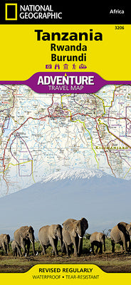
Home to Mount Kilimanjaro and some of Africa's most popular safaris, Tanzania has bountiful opportunities for adventure travelers. Covering the region with unparalleled detail is National Geographic's Tanzania, Rwanda and Burundi Adventure Map.

  • This expertly researched map combines topographical information, points of interest and a road network, making it the most comprehensive map available and the perfect compliment to any guidebook.
  • The map's front side covers the western half of Tanzania and the entirety of Rwanda and Burundi, along with Lakes Victoria and Tanganyika, and Serengeti and Ruaha National Parks.
  • While the reverse side covers the country's eastern half to its Indian Ocean shoreline as well as the islands of Mafia, Zanzibar and Pemba, the cities of Dar es Salaam and Dodoma, Selous Game Reserve, Ngorongoro Conservation Area and Kilimanjaro National Park.
  • Find cities, towns and protected areas quickly with a user-friendly index.

A mapped transportation network of major and secondary roads, tracks, border crossings, harbors, railway lines and ferry routes will help you get to your destination. Pinpointed on the map are national parks and reserves, kopjes, swamps, mangroves, areas of forest cover, scenic viewpoints, archeological sites, caves, churches, mosques, rock engravings, museums, hotels, lodges, campsites, beaches, diving areas, coral reefs and shipwrecks along with many other cultural, historical, ecological and adventure points of interest, including many hidden gems.

Every Adventure map is printed on "Travel-Tough" waterproof, tear-resistant paper.

  • Map Scale = 1:1,315,000
  • Sheet Size = 25.5" x 37.75"
  • Folded Size = 4.25" x 9.25"
Shipping & returnsShipping options, delivery timing, and our return policy.

In-stock items normally dispatch within 1–2 business days. The ZIP-code estimator on this page is informational only; the final shipping method, price, and availability are confirmed at checkout for your full order.

For the initial delivery estimate we use these transit windows after dispatch: Standard 5–8 business days, Expedited 2–4 business days, and Priority 1–2 business days. Holiday delays are not included.

Eligible items can be returned within 30 days in accordance with our return policy.

Customer reviews

M
AlbakiReads
Malaika Taylor

I highly recommend to for anyone looking for inner clarity

T
AlbakiReads
Thomas DiMassa

Great service and fast service

Great shopping experience! The book arrived quickly, was well packaged, and matched the description perfectly. I would definitely shop with you again

O
AlbakiReads
Olivia

Smooth.