Home › Super discounted books › Southern France Map

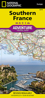
Southern France Map

- Waterproof - Tear-Resistant - Travel Map.

Regular price $14.98 USD
Regular price $27.24 USD Sale price $14.98 USD
Save 45%

Folded New

Delivery to your door
In stock·Dispatches in 1–2 business days Non-book item
Ground shipping* from $8.40
Ground shipping transit* 3–6 business days after dispatch

Economy Mail is not available for this non-book item; ground or parcel shipping applies.

Faster options are available.

Rates and delivery estimates depend on your destination and item quantity. Estimates are informational only; the final shipping method and rate are selected at checkout.

Secure checkout
American Express Apple Pay DiscoverGoogle Pay Mastercard PayPalVisa
30-day eligible returns Returns & refunds policy

Book overview

- Waterproof - Tear-Resistant - Travel Map

National Geographic's Adventure Map of Southern France is an invaluable tool for travelers seeking to explore the rich history, distinctive cuisine, and colorful landscapes of this remarkable region. Designed to meet the needs of adventure travelers with its detailed, accurate information, this map includes the location of cities and towns with a user-friendly index and a clearly marked road network complete with distances and designations for roads/expressways, plus secondary routes for those seeking to explore off the beaten path.

  • With specialty content to include hundreds of diverse and unique recreational, ecological, cultural, and historical destinations, this map is a perfect companion to a guidebook.
  • Among the many points of interest are national parks, campsites, beaches, ski resorts, golf courses, archeological sites, castles, churches, monuments, and more.
  • The front side of the print map details the eastern region, from its border with Monaco and Italy to the east, and the Riviera (Cote d' Azur), Mediterranean Sea and Golfe Du Lion to the south.

The reverse side of the map details Southern France's western region, extending from the Bay of Biscay to the west, Spain and Andorra to the south, and the Golfe du Lion to the east. Users will find a variety of helpful travel aids on this map as well, including the location of airports, railroads, and ferry routes.

Every Adventure map is printed on "Travel-Tough" waterproof, tear-resistant paper.

  • Map Scale = 1:465,000
  • Sheet Size = 37.75" x 25.5"
  • Folded Size = 4.25" x 9.25"
Shipping & returnsShipping options, delivery timing, and our return policy.

In-stock items normally dispatch within 1–2 business days. The ZIP-code estimator on this page is informational only; the final shipping method, price, and availability are confirmed at checkout for your full order.

For the initial delivery estimate we use these transit windows after dispatch: Standard 5–8 business days, Expedited 2–4 business days, and Priority 1–2 business days. Holiday delays are not included.

Eligible items can be returned within 30 days in accordance with our return policy.

Customer reviews

M
AlbakiReads
Malaika Taylor

I highly recommend to for anyone looking for inner clarity

T
AlbakiReads
Thomas DiMassa

Great service and fast service

Great shopping experience! The book arrived quickly, was well packaged, and matched the description perfectly. I would definitely shop with you again

O
AlbakiReads
Olivia

Smooth.